Home / Equipment / Georadar research
Georadar research
Russintek is using one of the latest non-destructive and non-invasive techniques for investigating subsurface and buildings - georadiolocation.
Georadar research or georadiolocation is a technique of non-destructive analysis of impulses reflected from the targets with different physical parameters. Georadar creates reliable 3D images of different objects with different depth.
When and Why You Need Georadar Research:
Subsurface survey
Subsurface investigation provides general picture, in fact “X-Ray” image, of subgrade - its layer composition and thickness, presence of ice or water-logged soil, slumping blocks and tectonic dislocations, hollowness, softening of ground, utility piping, ground and technogenic water limits, etc.
Conventional techniques used for field studies provide data of only point-by-point measured shears, while georadar research gives full and solid profile of sudgrade, which enables to detect potentially dangerous processes with minimum time and costs.
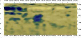
Georadar research. Washed soil in blue.
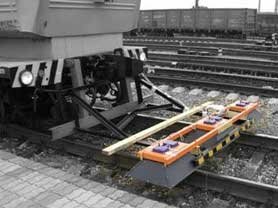
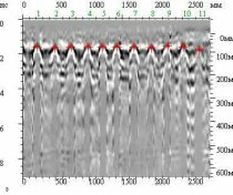
Rail track condition survey
Traditional techniques used here - geometrical measurement of track structure and rails defectoscopy - are often not enough to find out the reasons of rail-track deflection. Despite conventional studies, georadar research enables to see and localize slump blocks, ice and water-logged sections and allows to evaluate railway bed behavior and its improvement options.
|
Railcar with multichannel georadar sysem |
Foulness in blue after mathematic treatment
|
Highway survey
Main road destructions are caused by lack of information about their geologic structure and ground water behavior. Mistakes made due to the wrong assessment of ground and ground water conditions are costly and require daily eliminating activities. Conventional drainage ditch clearing and pavement strengthening are too expensive and last for 1-3 years only when new paving sees new defects as their reason has not been detected.
Georadar research allows to detect:
• depth of pavement constructional layers,
• types, dampness and consistency of pavement soil and underlying bed,
• ground water level,
• slip curve on sliding road sections,
• 3D profile of geologic layer base under the back of ballast bed,
• softening of ground, openings and infiltration of groundwater.
With data received chatterbump reasons can be easily traced and eliminated. Moreover, cost of research is much less than subsequent savings on road maintenance and repair.
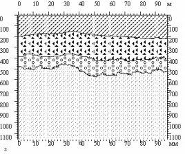
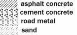
Interpreted georadar profile with impulse speed adjusted for each layer
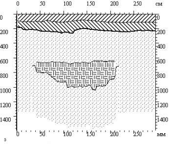
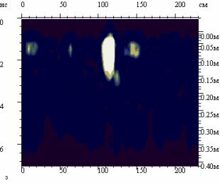
Footing and industrial flooring survey
In this type of investigation georadar helps do less coring, cut research costs and get full and reliable picture of footing or flooring along the whole perimeter.
Russintek did georadar researches at logistic premises of Tikkurila and StroyInvestProject companies. Georadar research helped in detecting deformation of steel layer and pavement depth disagree with specifications and projct documentation.
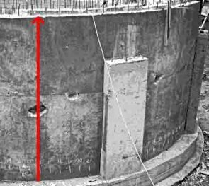
|
Georadar research of footing under construction |
The same footing exterior. Red arrow shows travel path of antenna assembly. See air spaces, which were detected by georadar |
Building parts survey (beams, slabs, columns, etc.)
Georadar allows to survey building parts effectively and with minimum time and money. It detects embedded cracks, uneven sitting, presence of reinforcing wires and their deformation, noncompliance with construction standards and project specifications. Currently, there is no any other device that can deliver the insides of building parts with the same precision and accuracy.
Georadar detecting reinforcing wires in the floor slab panel
Pipeline survey
When surveying pipelines the utilities should be under constant control and monitoring. That is why Georadar is so much needed here. Pipeline fracture causes watering, ground falling into the pipeline and its ablation. This creates air holes generating ground subsidence and its softening. There comes suffosion, further subsidence and then craters on the surface. To prevent this, it is crucially important to have clear picture of the utilities condition.
With georadar research we define pipeline depth, dimensions and condition, background medium, groundwater level and watered grounds. Use of georadar is cheaper, faster and allows not to turn off utilities for survey purposes.
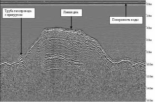
Georadar research of pipeline submerged crossing to define position and bottom profile around crossing
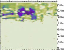
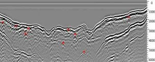
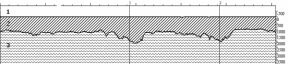
Water basin survey
Georadar detects composition of water basin foundation, ice thickness (for winter bridging over rivers), various metal pieces, including pipeline position relative to the basin floor.
|
Georadar research of freshwater lake. Red spots show objects in the bottom body. |
1.air 2.ice 3.water Interpreted georadiolocation profile with balanced flying height |
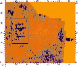
Archaeological survey
Georadar efficiency for archaeological surveys has been many timed confirmed with better quality and reliability vs conventional techniques used for digging.
Georadar research allows to find ancient and new anthropogenic and natural elements, develop routes for checking findings and new digging sites. With georadar research there is no need to use the invasive techniques for surveying the ground, which mitigates the risk of ancient monuments and relics destruction.
In addition, georadar research is time and cost effective and shows not only outlines of ancient colonies, but contours of necropolises, premises, graves, wells, trenches, difference and depth of occupation layer or continental ground burial, traces of ancient land divisions, drainage and irrigation canals and ground water shallowness.
The key georadar benefit for archeological digs is that you can use it on ground, water, ice and snow surfaces.
|
Georadar research at the archeological dig. Framed is the 18th century house footing
|
Georadar research at the archeological dig |